
 CFS3
CFS3Good grief there's some progress being made here! Wonderful what a fresh pair of eyes can do! This ought to be made a "sticky" before it's lost in the mire.


Good grief there's some progress being made here! Wonderful what a fresh pair of eyes can do! This ought to be made a "sticky" before it's lost in the mire.
CFS3 Battle of Britain Website: https://cfs3bob.wixsite.com/cfs3-bob
CFS3 ACC Member & ETO Expansion Group

Simply awesome ! Thanks so much ! Regards, Scott
I'm experimenting with trees to achieve a more solid grouping rather than the blotches of trees that we currently have. Tree density can be adjusted in the landclasses file for older pc's.
I will edit trees in the lcfview to try and place trees where they should be more or less.
Placing of excess trees could also serve the purpose of preventing repetitive tiling. I will have t take this into account as I go.
This and tree terrain textures are currently a wip.


A good idea. Random trees in fields is a pain!
Cato said "Carthaginem esse delendam"
I say "Carthago iam diu deleta,sed enim Bellum Alium adhuc aedificandum est"
Great work there R, like the idea of reducing the look of repetitive tiling with the trees.
Second WIP pic is excellent.
Cheers
Shessi
Random trees in fields is a pain
You'll probably still get some stray trees where the landclassess and different iso's in the same landclass intersect. It causes a bit of a mess where different city textures/iso's join as well. That is just the way the sim engine works unfortunately. I'm sure WOFF and WOTR have the same problem as well unless they have found a solution to prevent this.
I would like to remove trees if they are not meant to be in a certain position, but if their role is to prevent repetitive tiling then I will leave them where they are. Repetitive tiling is a real immersion killer.Great work there R, like the idea of reducing the look of repetitive tiling with the trees.
That's a huge improvement! May I ask that you can list what you've been doing at some point please, for posterity. Paint progs and the processes etc.
This is all superb stuff, you have succeeded where many others, myself include, have failed. I raise my glass to you sir!
CFS3 Battle of Britain Website: https://cfs3bob.wixsite.com/cfs3-bob
CFS3 ACC Member & ETO Expansion Group


Impressive work once again!
looks good
Absolutely awesome work. Thank you so much for the work involved. Regards, Scott
I created a large test square on the map so that I could see where googlearth fields and gardens can be placed between the trees on the mos texture that I'm using for the small city landclass.
This landclass will be used for villages and small towns.

That's looking every inch like Great Britain! Marvelous!
CFS3 Battle of Britain Website: https://cfs3bob.wixsite.com/cfs3-bob
CFS3 ACC Member & ETO Expansion Group
Thanks Clive.
For the moment I decided to use the above mos in the 'forest and field landclass instead.
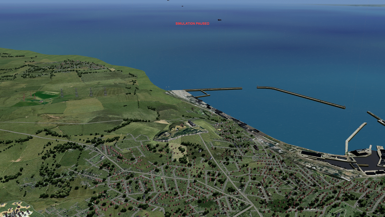
Clive kindly provided me with the source files for his Dover model. There were two separate models for the castle and harbour and after some headbanging I finally got Clive's two models into the sim.
I created a Dover castle m3d file, building file, and facilities xml file, but could not get the model to show up in the sim. I eventually realized, if I'm not mistaken, that a new model has to be added to the gsl.lib via the global layer.csv.
An easier way was to add the newly created ACC_Dover_Castle building and the separate harbour model to the existing GB-GC_Dover_Harbour.XML, and they showed up in the sim.
I have some other building models that I want to add to the sim, but that will probably be a later battle with the global layer process.
The harbour went into position without much fuss and I removed the castle's hill and trimmed Clives excellent castle model in gmax to finally get it into position on the terrain. It seems to be tailor made for that hill, who'da thunk.This screenshot reminds me that St Margarets on cliffe in the background needs to be moved further Eastwards, this was an initial rough placement just to see what it would look like.
I know that the red roofs have mysteriously popped up again, this will be remedied on release.

R,
That is superb, I mean, almost photo-real like, genuinely I'm amazed that it equals/betters Fs9 and early FSX stuff.
Cheers
Shessi
Originally Posted by rince33
 You're one to know
. It looks so much better than the stock stuff. It sure makes selecting a suitable field for a deadstick landing much more challenging! Very good and interesting work being done here - I'll be keeping an eye on this tread
ACC Member, ETO and PTO contributor & librarian
Yes , it does fit in well and looks a lot less 'fussy' than my arrangement. I was keen on getting the cliffs below the castle in, but probably made it too complicated.The harbour went into position without much fuss and I removed the castle's hill and trimmed Clives excellent castle model in gmax to finally get it into position on the terrain. It seems to be tailor made for that hill, who'da thunk. This screenshot reminds me that St Margarets on cliffe in the background needs to be moved further Eastwards, this was an initial rough placement just to see what it would look like.
Are you going alter the castle hill texture to make it blend in better?
CFS3 Battle of Britain Website: https://cfs3bob.wixsite.com/cfs3-bob
CFS3 ACC Member & ETO Expansion Group
I would have liked to preserve the hill on which the model was perched, but that bit of cliff in the front was out of place. At a later stage the cliff model could be extended towards the castle and the hill could be replaced.Yes , it does fit in well and looks a lot less 'fussy' than my arrangement. I was keen on getting the cliffs below the castle in, but probably made it too complicated.
The castle hill is part of the general terrain so I probably wont mess with it much if that was what you were referring to.Are you going alter the castle hill texture to make it blend in better?
As well as working on some new buildings, I'm editing the tree highlights. I've learned a bit a bit about using layers in gimp since I originally created those tree highlights and I'm sure they could look better close up.
I'm also adding googlearth fields to the a_047summer2_roads texture to add another mos/iso to the Forest and fields landclass, just for some variety.
Last edited by rince33; December 15th, 2023 at 03:47.
Taking a closer look at the castle texture the trees and some sections are probably a bit too green and could do with an edit. I'm listening to a lot of ww2 veteran testimonies as I have fun, cant really call it work. It's great that some folk are interviewing these veterans while some are still living. The vietnam testimonies are also pretty interesting.
I finally managed to get some of my own simple models into the sim using the global layer process. It was a time consuming pain in the arse, though now that I know a wee bit, it should get quicker and easier.
I learnt some things the hard way. Run the global lib bat and mkglob.exe as an administrator, and always check your edited facility xml files for syntax errors in the browser after editing.
Use an excel editor and not notepad to create the 'global layer.csv' entry. Its easy to leave out a comma, or enter info in the incorrect field in notepad, which can mess you around for some time if you are new to the process.
For model placement on the map, notepad can be used to adjust the co-ordinates as it's quicker and there's less chance of making errors, and most importantly, always read the tuts thoroughly and even twice through, to ensure that you fully understand what you need to do.
I still need to create a mos file airfield for the models, so I hope that proceeds more smoothly.
If anybody has any advice it will be appreciated.
The simple models were created in Gmax. You don't completely lose the ability to create models in 3dmax even after 20 yrs since last using the program.
The gmax ui is more natural to use than blender, but texture mapping is more time consuming. In blender, the mapping can be done in edit mode, selecting a few faces at a time for quick and easy mapping.
This is the Ramsgate civilian airfield terminal building and accompanying hanger.

Last edited by rince33; December 19th, 2023 at 04:27.
I finally managed to get some of my own simple models into the sim using the global layer process. It was a time consuming pain in the arse, though now that I know a wee bit, it should get quicker and easier.
Nice models there
I learnt some things the hard way. Run the global lib bat and mkglob.exe as an administrator, and always check your edited facility xml files for syntax errors in the browser after editing.
Use an excel editor and not notepad to create the 'global layer.csv' entry. Its easy to leave out a comma, or enter info in the incorrect field in notepad, which can mess you around for some time if you are new to the process.
I don't get your global layer issues and use of an excel file. I do a lot of global layer work using Libre Office spread sheet; all data in columns, not the word string separated by commas, etc. I would never bother with notepad or anything other the spreadsheet in columns.
For model placement on the map, notepad can be used to adjust the co-ordinates as it's quicker and there's less chance of making errors, and most importantly, always read the tuts thoroughly and even twice through, to ensure that you fully understand what you need to do.
One way of placing items on the gsl is to use a driivable jeep or similar, and actually drive it to where you want with the 'z' coordinate key in action. If you can't actually drive therer, I have used a storch or similar slow aircraft flying just above the ground.
I still need to create a mos file airfield for the models, so I hope that proceeds more smoothly.
If anybody has any advice it will be appreciated.
The simple models were created in Gmax. You don't completely lose the ability to create models in 3dmax even after 20 yrs since last using the program.
The gmax ui is more natural to use than blender, but texture mapping is more time consuming. In blender, the mapping can be done in edit mode, selecting a few faces at a time for quick and easy mapping.
This is the Ramsgate civilian airfield terminal building and accompanying hanger.
Cato said "Carthaginem esse delendam"
I say "Carthago iam diu deleta,sed enim Bellum Alium adhuc aedificandum est"
Hi Mongoose, and thanks for the advice. I didn't know about the 'z' co-cordinate key.
I was using notepad which was causing me problems, and then I downloaded 'Free excel viewer', which placed the data in columns.
,

That's the answer and I assume you know how to use CFS3 Terrain SDK\GlobalLayer.
Cato said "Carthaginem esse delendam"
I say "Carthago iam diu deleta,sed enim Bellum Alium adhuc aedificandum est"
Yes, I used it to get those two models into position, but it took me about 2 hrs yesterday morning.That's the answer and I assume you know how to use CFS3 Terrain SDK\GlobalLayer.
With your advise about using the 'z' key it will now be a lot quicker. Thank you.
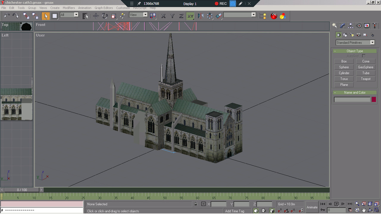
Work on Chichester cathedral model. I created this model in blender a while ago for an il2 channel map . It's a low poly version of the Bob2wov model, which I used as a guide. I'm busy skinning it in gmax. There are a few more pieces to add add and then it will be ready for placement.
 Members who have read this thread: 69
 Posting Permissions


Bookmarks